
Yosemite NP
|
Delaney Meadow & Lembert Dome Yosemite NP |
July 13, 2015
I am excited about this first visit of the year to my beloved Yosemite
high-country. Having felt the need to leave home at the
ungodly hour of 4:30 a.m, I have reached Olmsted Point by eight
o'clock. Amazingly enough, I can see that at least two persons already
have accessed the summit of Half Dome. They must have started up at
daybreak, because it's a 2600-foot climb from Little Yosemite
Valley Campground, the normal staging area.

There are some hikers on the cables as well

A dozen miles farther east is my trailhead at the base of Lembert Dome. It already is warm enough that I will not need to carry any sort of additional clothing.

This must be the way

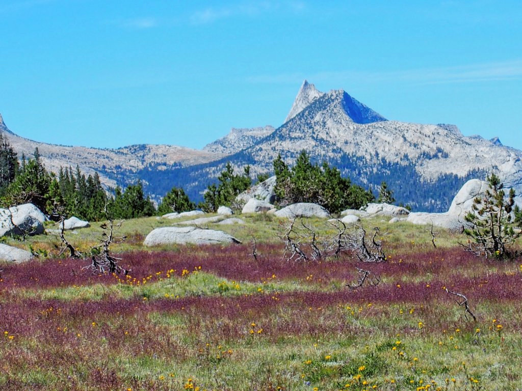
The Cathedral Range to the left
Actually, a second cairn tries to route me westward; so I must go back and find the trail heading north from the big slab.


The trail alternates between rough and smooth

Lobb's Buckwheat

Alpine Aster

Wandering Daisy

Nuttall's Larkspur
Ignoring the Dog Lake cutoff after one mile, I continue northward, reaching the anticipated open area within two miles.

Delaney Meadow and Peak 10410

Delaney Creek drains the Skelton Lakes
I can see no use trail leading upstream. I find a place to jump the creek; but it proves not to be such a good spot after all, because I get some water in my left boot. A few minutes later, I must make another crossing, during which I now get water in my right boot, which seems only fair.

Lemmon's Paintbrush

Sierra Ragwort
I am up in this meadow because I had read that it is a great place for flowers; but today's selection is mighty slim. It must be too early in the season yet for best effect. Last week's glorious display at Carson Pass, at the same elevation, apparently is not a good indicator of conditions in this area.

Sierra Penstemon

Dwarf Lupine
As usual, hugging the creekside isn't the smoothest route; but the going is fairly easy anyway, through a forested area then back out into the meadow.


The creek is quite pretty
Above me is the mountain designated as Peak 12002 on the topo map, also informally known as False White Mountain.

I plan to hike over there tomorrow
There is an ongoing campaign to rename that mountain as Sharsmith Peak in honor of beloved park ranger Carl Sharsmith, "The Mountain Sage". Because Peak 12002 is on the Yosemite Park boundary, however, it has been suggested that there could be a naming conflict with another federal agency or two. On the other side of the mountain are the Hoover Wilderness and the Harvey Monroe Hall Natural Area. I guess that more than one map might have to be changed in that case; so when Dr. Sharsmith finally gets his due, it might well be a different peak that ultimately is renamed.
Nice grasses
Originally I had planned to try for the first Skelton Lake; but it still
is nearly two miles away, with another 900 feet of off-trail climbing
involved as well. Doubtless the views get much better over there; but because
I have a major adventure planned for tomorrow, I will start back from here.

White Mountain, 12057'
Of course, returning by the same route is unthinkable whenever there is a reasonable alternative. The terrain is mild here, and thus far the forest has been forgiving; so I will detour back past some ponds that are shown on the map, with GPS in hand.

Turning south
Within a quarter of a mile I encounter the first pond. No fish are in evidence, of course; but there are a couple of nice flowers.

Pond #1

Red Mountain Heather

Little Elephant Heads
The next objective is a half-mile to the south, through some deeper forest.


The GPS says to go this way

Silky Lupine

Labrador Tea


Pond #2 and one of its residents

An amazing tree adorns a tiny island
Another half-mile begets the biggest pond yet:

Pond #3

More froggies-to-be
Bugs have not been an issue as long as I was moving, but stopping to munch some gorp necessitates the application of some mosquito repellent. About eight feet away, a dragon fly entertains me:

Doing whatever dragon flies do
The map says to turn westward now, toward the next waypoint.

Pond #4
Okay, I've seen enough ponds for one outing. It is time for something more meaningful.

This is more like it
My first visit to Dog Lake does not disappoint me. The
crystal-clear waters gently lap the shoreline with hardly a sound.

In the Sierra at least, the eastern shore invariably is where all the action is


I am the only person here at this good-feeling place
The sun feels so good on my back. I could enjoy staying here indefinitely, but no; I seem compelled to move on.

Pond #5
It is not far to Lembert Dome now. Being so close, I might as well climb it again. The last time I tried to find the way up, I was dealing with snow banks; today, I merely must access a high point to see how to proceed.

That-a-way
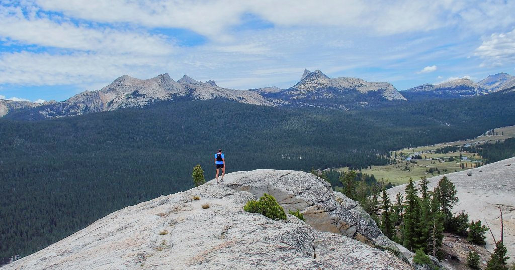
The summit of Lembert Dome is accessed from its northeast corner, and that's where I am now. Walking alongside a cliff, I turn upward onto the slabs as soon as the going isn't too steep.

Coming down the dome
The 300-foot climb is dispatched in short order. Unlike my previous outing in 2011, when I had the whole place to myself, there are several other hikers up here.

Lembert Dome, 9449'
This time, I veer around to the left so as to reduce the gradient.

That's the hard way
That looks like me, about forty years ago
The skinny dude promptly disappears over the 'edge', not to be seen again.

This is the easy way up
Naturally, there are outstanding views all around:

Mount Lyell, #1 in the park at 13114', sports the region's biggest glacier

Mount Dana, #2 at 13061', has a dusting of snow

Mount Conness, #3 at 12589', is way up there to the north

Parker Pass to the south

Tuolumne Meadows to the west

Sierra Stonecrop are the only flowers up here today.
On my previous descent I elected to plunge straight down the eastern slab. At the bottom, I was compelled to slide the last ten feet off the rock, whereupon I slid too fast, cutting my hand on a stone in the process. Although I am not wearing my 'slippery' pants today, I opt to exit the dome in the standard manner anyway.


It's 500 feet down
There is a pack trail just east of here. It hardly seems worth the bother to head over that way, though, because a straightforward scramble down the steep hill is available.

Puppy Dome is half a mile south, across the highway by the big campground

There's the highway

This Mariposa Lily is popular today
My descent ends directly across the road from the pack station.
I knew that in advance, because I could both hear and smell the animals.
Another short half-mile walk beside the road gets me to the trailhead.


Back at the parking lot
§: Well, Delaney Meadow was on my bucket list, and I'm glad
that I did this walk; but every other option in this area rates to be more
exciting. For the more energetically inclined, I have seen pictures
of the Skelton Lakes area, and it is awesome.
In retrospect, however, although my standard perceived necessity of
preserving strength for a subsequent outing has manifested itself once again,
I cannot recall ever having complained during a hike about having walked too
far on the previous day. It sounds like a lazy copout; and perhaps I
need finally to start living for the moment rather than putting stuff off for
tomorrow. I am beginning to run somewhat short of tomorrows —
at least, ones on which I will be able to do strenuous hikes.
| Scenery |  |
| Difficulty |  |
| Adventure | |
| Solitude | |

